Saturday, August 14, 2010

Gorged out in Katherine

(6-9 August 2010)

So onto Katherine as we edge ever closer to Darwin, where we stay at another homestead, this time the Springvale Homestead, some 7km west of the town centre. And another campsite with some wildlife in some wallabies, many birds including ducks, geese and some ugly birds we first saw back near Tolga in the Atherton Tablelands, which we are still yet to identify, plus a crocodile on the opposite bank of the billabong (pond).

And, yes there was no fence to the billabong, but the crocodile was most likely a freshwater variety, and therefore less threatening than the saltwater kind.

On the Saturday, we check out the markets – where there was a high percentage of Thai/Malay food stalls (laksa anyone at 10am?). We bought some locally grown watermelon (the ones with seeds!), small bulbous aubergine and scrummy, sweet cherry tomatoes.
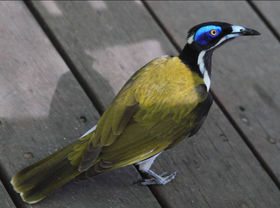
In the afternoon, we drive into Mitmiluk NP for some Gorge action, only to watch M take a quick dip in the river at the first gorge – yes the one they recently closed due to a saltie. We didn’t do a gorge cruise – the tribe not too keen on going on boats – nor did we do a walk as it was estimated to be an equivalent of 40C on the bushtracks. We were however entertained by the blue-eyed honey eater and the short-eared rock wallaby.

On the way back to the campsite, we stop at the Katherine Hot Springs for a dip – not as warm as the Mataranka Thermal Pool, yet it is a great place to unwind and relax, which the tribe enjoy – and enjoy it so much, we return again the following afternoon.

Sunday – well this Sunday was not like any other Sunday as it was the trio’s 4th birthday! And to kick things off, we had pancakes - okay, we have pancakes most Sundays – but the trio each had a stack with a candle. After brekkie, Saffiya handed out the presents to Kaydin, Zak and Soraya, plus she received a few herself.

M carved and decorated three separate cakes, so that each of the trio had their own cake and we all sang ‘Happy Birthday’: Kaydin at morning tea, Zak at afternoon tea and Soraya at dessert. Giving each of them their special attention made the birthday just that little bit more exceptional, as they are all exceptional little people.

So three cakes in one day – we were stuffed!


The Tribe of the Never Never

(5-6 August 2010)

After a typically late start – we’re the last of the travellers to depart Newcastle Waters, we continue north along the Stuart Highway towards Mataranka. Passing many apparent sites of interest – especially if you’re into all things WWII – which we pass on, we do however make a stop at Larrimah for a lunch break.

The curious place that is the Larrimah Hotel is worth the stop – you are welcomed by an oversized NT Stubby (5 metres tall at a guess) accompanied by a lounging Pink Panther. Also, around the ‘gardens’ of the hotel in which you can freely wander is what they call a ‘zoo’ but lets just call it a menagerie. The collection is mainly of native birds – finches, parrots and the like, plus some emu chicks (cute as!), a bearded dragon, and docile (ie asleep) crocodile. The tribe were a bit under whelmed by the croc, but loved the emu chicks.

To supplement our picnic lunch, we grabbed a couple of Fran’s homemade pies (a couple hundred metres up the road from the hotel) – I went the safe beef option as I don’t think the tribe would take to buffalo or crocodile pies. And what a winner – the tribe couldn’t get enough of Fran’s, despite it looking like something a dog threw up (there was a pile of mash and vegies drowning in HP sauce atop the pie).

We reach Mataranka and stay at the Mataranka Homestead which adjoins Elsey NP where we take a dip in the crystal clear waters of the Mataranka Thermal Pool. The water is a constant 34C and despite the day’s temperature being around 30C, the pool was a gorgeously relaxing experience.

Taking the tribe for the short walk around this part of Elsey NP, we wander past the Thermal Pool and take in the view of the river where we spot archer fish near the bank, although we didn’t get to see them spit at any unsuspecting insects.

As for camping at the Mataranka Homestead, the tribe were raptured by the sight of a couple of peacocks, peahens and wallabies around the campsite. Also, a bonus for all you film buffs, and in particular, Australian film fans, is the Elsey Homestead replica built for the 1982 film We of the Never Never, just lacking the presence of Angela Punch MacGregor.

Over the border and playing with the Devil’s Marbles

(2-4 August 2010)

So, we leave the Isa and head for the border town of Camooweal, just 13km inside Queensland and refuel before crossing into the ‘Territory’. And it does feel like the last outpost – just a stone’s throw from the border (and another time-zone).

No sooner than we cross the border and we are hit by amazing cross-winds blowing over the grass plains, buffeting our drive into the Territory. The winds are so strong that driving is a struggle compared to all previous days – and despite the slower speed at which we are forced to travel, the fuel consumption takes a hit too.

We camp at Wonarah Bore (43km east of Barkly Homestead; 19 50 33 S / 136 09 23 E) for the night, trying to find a protected area to camp out of the wind, but there is no hiding from the gusts today/tonight. The best place out of the wind was in fact in a hollow – possibly a former damn, but we’d never get the car or camper-trailer out, so we weather the gusts.

At night, the wind howls in that clichéd way, whistling just like in the movies and often it feels like the camper-trailer would blow over, the wind giving our home a damn good shake. Come day break and the winds have subsided, the air crisp and the sky blue.

The Barkly Highway is our route until we hit the Stuart Highway and after refuelling at the Barkly Homestead we reach the Three Ways Roadhouse for our lunch stop and a photo opp with a couple of road trains. After lunch, we head south to the Devil’s Marbles (Karlu Karlu)and a little further to Wycliffe Well (the Australian hotspot for UFO sightings).

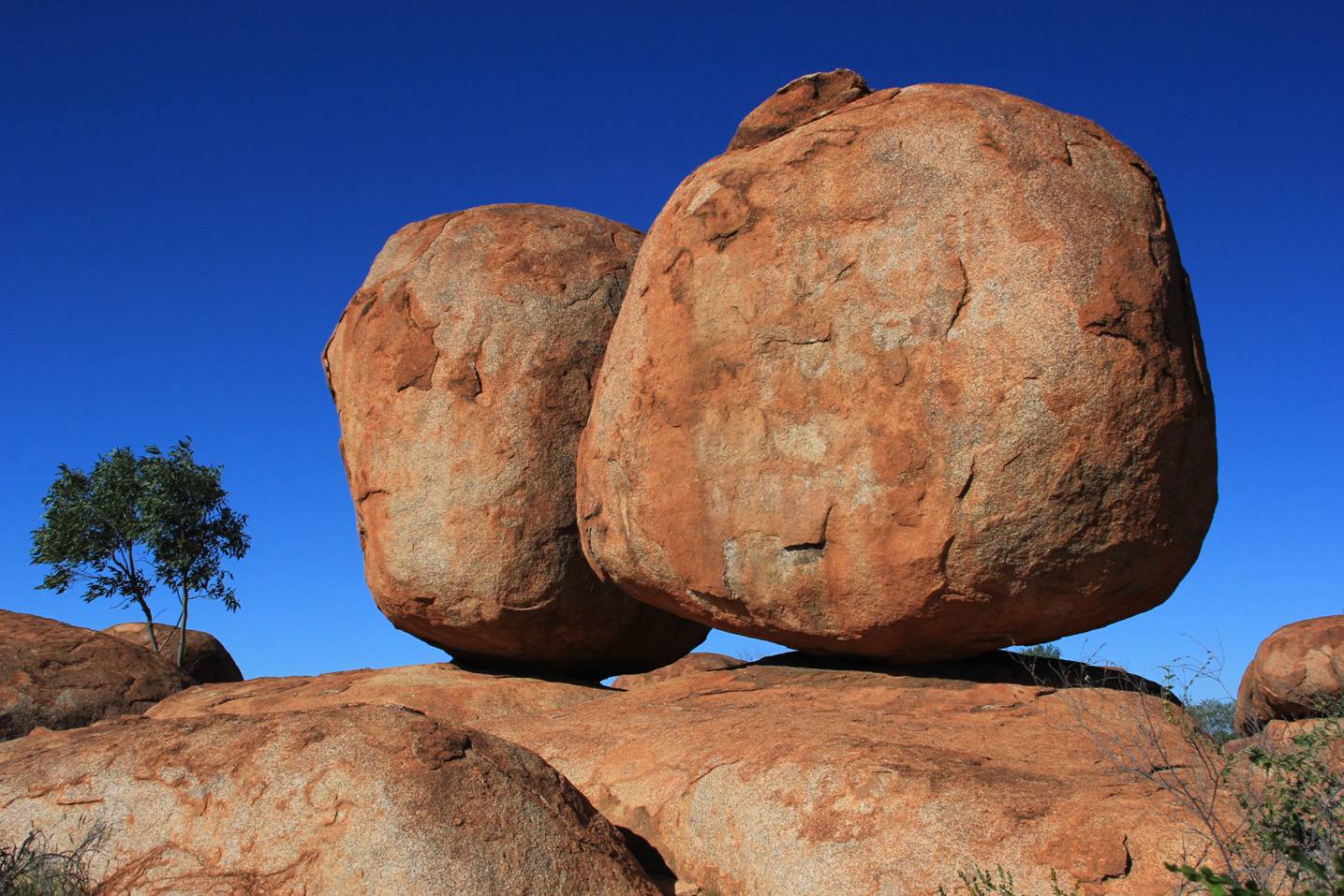
The Devil’s Marbles is a most peculiar spectacle in that out of nowhere appears a collection of huge boulders scattered about an area, where on either side are plain, low undulating grassy hills. More peculiar are the boulders balanced on each other as if some giant had placed them. Anyway, the local aboriginal lore describes the marbles as the eggs of the rainbow serpent – and I’m glad these are eggs that won’t be hatching ‘cause they’d be some damn huge serpents let loose upon the landscape.

We spend the night at Bonney Well (87km south of Tennant Creek; 20 25 48 S / 134 16 10 E)) – and thankfully there is no wind tonight. Saffiya joins me for a walk around the rest area and down to the Bonney Creek to do some photography – I reckon she’s showing some talent (see photo on the left). We spot many little flowers and some fast and deftly flying finches (not too sure of the type as these were fleeting by to their mud nests hanging under the road overpass).

In the morning we push northwards up the Stuart Highway, passing through Tennant Creek and Renner Springs – a town-that-had-seen-better-days.

After a brief ice cream stop and refuel at Elliott, we spend the night at Newcastle Waters (17 22 31 S/ 133 32 33 E) rest area – a small and crowded free camp by the roadside. The view eastwards over the plains below make for a picturesque setting especially for the sunrise the next morning.

Friday, August 6, 2010

Now we’re REAL Aussies!

(31 July - 1 August 2010)

Every town has a welcoming sign, usually in spirit of the “This town welcomes you – enjoy your stay!”, however, the sign that you sight as you drive into Mt Isa from the east reads: “Welcome to the Isa . . . Now, you’re a real Australian!”. So, what does that say about all of you who have yet to visit the Isa? Fakes – the lot of you!

And, you thought, just by supporting the Wallabies or the Socceroos made you an Aussie – pah! Now you know what you actually have to do – visit the Isa, obviously!

Anyway, the drive into Mt Isa, and the initial view of the town from the hills around, with the smoke stacks and surrounding rocky scenery is reminiscent of scenes from Mad Max 2 (aka The Road Warrior). And what of the place?

It’s still the mining town it has always been – in fact there is a personal connection to the place for me as it was 39 years ago, my dad came up here for a job interview, and as part of the benefits, each family was given a return flight to Cairns each month to do their groceries as there was no supermarket in town. The prospect of the isolation and living off frozen food for a month deterred my parents so we ended up in Wollongong instead.

The best thing about Mt Isa, if you’re a kid (and if you’re a parent – natch!) is that’s home to Queensland’s largest all abilities playground, which features rides, climbing frames, flying foxes, water-park and skate(board) park. The tribe couldn’t get enough of the place – especially when they discovered there were also some state-of-the-art toilets which spoke to you (“Your time is 10 minutes”), followed by muzak and automatically fed out a set amount of toilet paper.

We ventured a little out of town to visit Lake Moondarra, where we watched either whistling kites or little eagles soar and dart about seeking prey. Much to the tribe’s dismay, the only other wildlife were a dead turtle on the grass and deceased bats caught in the electrical cables.

Doing the Dinosaur

(29-31 July 2010)

Heading west from Townsville we bypassed Charters Towers to reach our first night’s stop on the Flinders Highway at Campaspe River Rest Area, about 90km west of Charters Towers. Not much of a river this time of year, but the place is green thanks to the big wet earlier in the year.

The next day, we continue the drive westwards towards Mt Isa and the Northern Territory border. The road takes us up an ever so gradual incline as we reach the top of the Great Dividing Range, our connection to home at 550 metres above sea level, which is actually higher than Springwood. Even with the height advantage, strangely, we couldn’t see home from here!

So what is there to see along the Flinders? A lot of flat grazing land as far as the eye can see in all directions, so that much of the road here is straight, dead, boring straight – but we take it as a little early practice for our drive on the Nullabour in future months to come.

Our stop in Hughenden was an introduction to dinosaurs for the tribe; they met ‘Hughie’ in the street and the skeleton of the swamp-dwelling Muttaburrasaurus at the Dinosaur Museum and Information Centre. As the tribe were sleeping, we had to forego Richmond, another of the dinosaur towns and home to the elasmosaurs, kronosaurus Queenslandius, and pliosaur.

Somewhere after Hughenden, there were parts of the road with a dense curtain of the gold and green of acacia on either side, like a guard of honour – something that provided a relief from the dullness of the drive so far.

After the acacia, much of the landscape that accompanies us is again dead flat – grasslands with occasional clusters of shrubs as far as the eye can see. And when you reach the place where your eye could see the furthest, there’s even more of the same as far as the eye can see. Did I mention this was a boring drive? No?

Well, it was a tad boring, despite seeing the mercury hit 38C in the mid-afternoon – our hottest day on our travels.

We did get into the habit of waving (actually just a lazy raising of the hand, or even lazier raising of the forefinger from the steering wheel) to passing caravaners and occasional others, as others did to us – must be an outback thing to pass the time, although there is a strange masonic aspect to the wave.

Our second night along the Flinders was at Max Welton Rest Area, 50km west of Richmond – where we swapped travel hints with a young German couple – they’d just come from the NT, and had about four weeks to do Cairns down to Sydney, as they had spent longer than expected in their trip from Adelaide to Darwin.

A couple of other beaut things about this spot:
• there is a plague of locusts heading east and south – the place sky was dotted with them!
• the suggestion from a former worker who was camping the night, of the bore 200 metres north of the rest area for a warm water wash (fresh warm water from the Great Artesian Water Basin!);
• it was the first time I have seen night chase day and day chase night across a flat expanse – quite a fascinating experience being in a spot where you straddle night and day under the huge expanse that is the sky.

From Cloncurry to Mt Isa, the landscape changes quite dramatically – no more are the flatlands surrounding us as far as the eye can see, as now there are undulating hills interspersed with dramatic rocky outcrops with the soil a vivid red, darker and richer than in the land east of Julia Creek. At Cloncurry, we enjoy a picnic lunch, the town, famous for being the first Flying Doctor base and experiencing the highest temperature on record (53C!), yet for us, it was an anticlimactic 28C.

Sunday, August 1, 2010

What’s another name for Townsville?

(27-28 July 2010)

After the rain we experienced in Cardwell, we were in need of drying out, so we hoped Townsville would be the solution. This was also to be a major refuelling stop – refuelling food stocks, getting the car serviced, and catching up with (Aunty) Kim and Josh.

However, initially, it seemed that Townsville was not going to be the place for us as most caravan parks were full or didn’t want kids (two van parks advertise they cater especially for the over 55s). Ultimately we find a place but for only two nights instead of the three we planned.

We catch up with Kim and Josh (and Kiki) on our first night – a very yummy spaghetti Bolognese – and get some tips on what to do in town.

And based upon Josh’s tips, we visit the Riverway for a picnic, play as well as feed the turtles, ducks and fish, before putting the car in for service. M takes the tribe to unfortunately, one of the smaller shopping centres, while I wander about town as the car gets seen to. Unfortunately, barring a fleeting visit to the Regional Art Gallery, I don’t see much of what Townsville centre has to offer due to the Flinders Street redevelopment, the place is suffering a soul famine.

We do however get friendly with a native as we packed up before heading out of Townsville – a white-lipped green tree frog made a temporary home in our caravan park electrical box.

The tooth fairy is beginning to work overtime in keeping up with Saffiya (and our travels) as she loses her second tooth in five days, making it now three in total!

We’re just opposite Hinchinbrook Island

(25-26 July 2010)

As we head down the Palmerston Highway from the Atherton Tablelands to rejoin the Bruce Highway near Innisfail, we are hit with thick mist and drizzle. This does not offer a good opportunity to stop at the rainforest canopy walkway at Mamu, so we continue onto Cardwell by the Sea.

Well, what can you say about Cardwell that hasn’t been said before? Well, you wouldn’t holiday here in the rain as there’s not much to do. You wouldn’t come here to swim as there’s crocodile warnings all along the beach. You could take the ferry to Hinchinbrook Island. You could fish from the jetty. You could buy some succulent fresh Barramundi steaks from the butcher (yes, butcher) and barbeque yourself a damn fine dinner.

Since the weather was lousy, I definitely recommend the latter – as it was damn fine (oh, I already said that didn’t I?)

As there’s not too much doing, we head south of town and visit Five Mile Creek which is the local swimming hole, with turtles, catfish, eels (and other fish) plus warnings for bullrouts (lethal fish, if you so happen to step on the spines of one – related to stonefish). And back in town, the interpretive display at the Rainforest and Marine Information Centre was a good distraction for Saffiya and Kaydin . . . for about 10 minutes.